
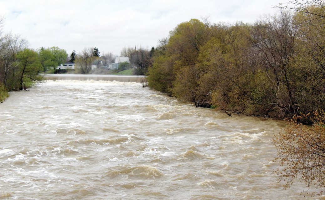
The rain this week has increased the levels and flow of water of the Nation River over the Crysler Dam. Thompson Goddard photo
Candice Vetter
Villager Staff
ROCKLAND – Flooding of properties along the northern edge of the United Counties of Prescott-Russell beside the Ottawa River continues and there is no quick end in sight. Hundreds of people have been evacuated from Clarence-Rockland, Plantagenet and from other locations near the river’s edge. Ferries across the Ottawa River from Quyon to Cumberland to Thurso have ceased running, and towns like Ste-Anne de Bellevue and Rigaud on the St. Lawrence are also dealing with significant flooding. In fact, any properties alongside creeks, rivers or lakes in Eastern Ontario and Western Quebec are under flood warning, meaning flooding is occurring or is imminent. In the City of Ottawa the Chaudiére Bridge is being carefully watched as the roaring run-off is only a couple of feet below the bridge.
On Mon., May 8, Champlain Township also announced evacuations due to flooding of the South Nation River near L’Orignal. Premier Kathleen Wynne visited Rockland on Mon., May 8, where she met with local MPPs Grant Crack and Marie-France Lalonde, then continued on to L’Orignal.

Heavy rains throughout Ontario and further east, immediately following the spring snow melt, have swollen waterways beyond capacity. In the South Nation watershed, the spring snow melt caused the Castor and South Nation Rivers and their tributaries to crest about two weeks ago. Additional precipitation, including two rainstorms last week which each dropped 25mm (about one inch) have now raised water levels high above the normal crest. These waters are carried downstream to the Ottawa River, which is very high, partly because of the heavy rains and partly because the river is one of the few Canadian rivers which flows south, meaning its northwesterly sources are still experiencing spring melting. At the Ottawa River’s confluence with the St. Lawrence River near Montreal, the situation is compounded as heavy rains also affected the Great Lakes basin, which empties into the St. Lawrence.
Islands in Montreal, Toronto and Ottawa have been submerged, including Toronto Island (which houses the Billy Bishop Toronto City Airport) and Petrie Island near Orleans. States of Emergency have been declared in Ontario and Quebec.
In Russell, well-known community leader Connie Johnston organized a flood and drink run to Rockland on Sat., May 6. “We filled two vehicles with drinks and food and took it down to about four sites,” she said. “Such devastation – it is unbelievable. They were so appreciative. And once again the people of this village were so amazing. I decided to do it on Friday morning. By Saturday morning, I must have had 20 people participating, some staying up all night to bake. And the three businesses that helped me were amazing: Karine Boucher at Foodland, Winchester Tim Hortons and Ches Woolfrey – owner of Shoppers Drug Mart in Embrun. Ches’s wife Wanda sent two huge rough neck containers of all handmade food. We found a dead-end street with houses at the end (almost impassable to get to them) that were working so hard to save their homes. They actually cried when we arrived with the food.”
South Nation Conservation has cautioned residents, saying, “Water levels in the Ottawa River are currently significantly high and will continue to increase.” On May 8, SNC reported water levels at Gatineau and Thurso gauges were 45.18m and 43.69m and were forecasted to continue to increase by another 12 to 14cm, causing significant flooding between Gatineau and Hawkesbury.
SNC said, “Residents are advised to stay away from watercourses where flows are high and where banks might be unstable. Parents are encouraged to explain these dangers to their children.” These warnings have been consistently given out by the OPP as well.
The OPP in Rockland also stated police have been receiving complaints from the community of motorized vessels on the Ottawa River causing wakes to overflow the sandbags along the City of Clarence-Rockland shoreline.
“Due to rising waters in the flooded area, the OPP would like to discourage members of the public and residents in using their motorboats or Sea-Doos within the City of Clarence-Rockland, as the larger wakes are causing more damage. The OPP is aware that conditions in the area are changing and will utilize whatever resources are required to best serve those who have been evacuated, and those who have chosen to remain with their homes at this time.” The OPP has stated that its primary focus is to ensure the safety to those who are being affected by the flood.”
In the Township of Clarence Rockland the local flood hotline number is 613-446-1518 and volunteer registration is 613-488-2960. Shortly after noon on Sun., May 7, sandbags were all used up in the township, but more were on their way. The municipality is asking motorboaters to avoid any areas suffering flooding and asking people who are not directly helping to avoid flood zones, particularly Voisine Rd. and County Rd. 17 in Clarence Rockland. In the Nation Township, County Rd. 9 is under water for the second time this spring. In the Outaouais region, Highway 50 is closed for long stretches and Quebec police are asking the public to stay off that road.
The OPP also ask the public to visit www.nation.on.ca for flood warning updates and to report non urgent changes in water-related conditions, instead of calling 911.
SNC asks the public to also report changes in water-related conditions, soil stress fractures (i.e. cracks in soil), abrupt changes in streambanks, or sudden leaning of trees in their local areas. All feedback and photos can be sent to waterwatch@nation.on.ca, posted on its Facebook page (/SouthNationConservation), or tweeted to @SouthNationCA. Additional information on Ottawa River levels can be found at www.ottawariver.ca.
In this area where Leda Clay, one of the weakest soil types, is predominant, an additional danger is posed by landslides. In Orleans, several houses backing onto Bilberry Creek were evacuated last Thursday when the ravine behind them slid away. Heavy rains can destabilize Leda Clay by suddenly flattening the marine clay’s crystalline structure, which caused the Lemieux landslide in 1993.


