
Revealing lost history
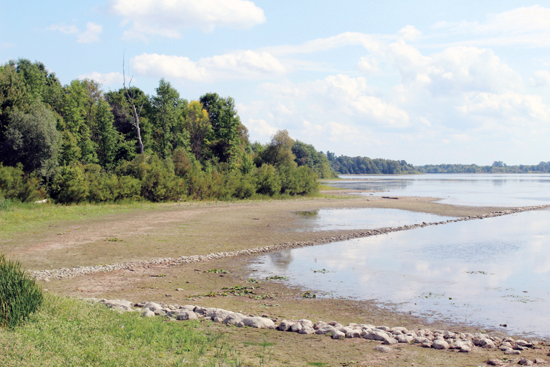
The waters of the Hoople’s Creek continue to recede as water levels are lowered by the International Joint Commission seeking to lower the water level on Lake Ontario by increasing the water flow at the Moses-Saunders Dam located near Cornwall. A photo taken on Sun., Sept. 16 shows an “old stone fence on the farm that was east of Hoople’s Creek, in the first concession, near Wales” which was identified by local historian and past president of the Lost Villages Historical Society Jim Brownell of Long Sault. Thompson Goddard photo
Kalynn Sawyer Helmer
Record Staff
LONG SAULT — The meeting room at the South Stormont Township hall seemed to shrink as residents from across waterfront townships packed themselves into the arranged chairs, against the walls and throughout the room, wherever space allowed on the evening of Tues., Sept. 11. The atmosphere was tense with dismayed residents, eager to ask their questions and hear from invited guests, members of the International Lake Ontario – St. Lawrence River Board.
Cliff Steinberg, St. Lawrence River waterfront property owner and long-time advocate for communication between the interest groups, organized the evening after a summer of damaging low water levels. Concerns ranging from degraded tourism, endangered wetlands and animal habitats, waterfront erosion, shipping and recreational concerns were all acknowledged during the meeting. Unfortunately for the residents, short-term solutions were nowhere to be found.

Jamie Dickhout, alternate Canadian regulation representative, International Lake Ontario – St. Lawrence River Board, was the guest speaker of the evening. She kicked things off with a presentation on how flows are managed, current conditions and future expectations. Her presentation did little to ease concerns but it was Rob Caldwell, manager, Great Lakes-St. Lawrence Regulation Office, Environment and Climate Change Canada who came under fire during the evening. This was in part to the divide between desired outcomes for the meeting between the board and the residents. The former, wanting to field concerns and retreat to meetings to deliberate further and the latter demanding answers in the moment.
Steinberg later opened the floor to comments from stakeholders. With such low levels this year, concerns were heard about minimum and maximum water levels for the St. Lawrence. Steinberg said there were regulations for the shipping areas, yet no confirmation could be garnered for the recreational areas and shorelines. This is in contrast to the strict regulations for the levels on Lake Ontario which may only be regulated up and down by two centimetres.
It was difficult for many in the room not to protest the difference and while speaking with the Chesterville Record after the meeting Caldwell aimed to explain. “The main objective of Plan 2014 is to better mimic outflows over the long-term. So, ultimately the only way that we can do that is by increasing the range of water levels that we see; not only on Lake Ontario but also on Lake St. Lawrence,” he said.
Caldwell continued that by mimicking nature it “thereby restores 53,000 hectares of wetlands in the Lake Ontario, Thousand Islands reach of the St. Lawrence River. So basically above Iroquois Dam there are 53,000 hectares of wetlands and they have been largely impacted. The biodiversity in those wetlands has been reduced by irregulation of the outflows here at the Moses-Saunders Dam.”
For the scientists who studied the effects over 16 years to establish Plan 2014, Caldwell said they, “worked within certain parameters in establishing what wetlands would be sensitive to changes in the regulation plan. Lake St. Lawrence notwithstanding; obviously they realized that, but the size of the wetlands here are somewhat limited versus the size of the wetlands that we are talking about around, say, Prince Edward County, certainly along the south shoreline near Sackets Harbour, these sorts of huge wetlands.”
While he was not involved in that part of the project, he did say, “maybe they had to focus on the best bang for the ecosystem-buck; where we can provide the fastest or biggest benefits to biodiversity in changes to the regulations.”
All of this contributes to the news that residents received during the evening that closing the Moses-Saunders Dam to raise water levels, is not an option under the regulations.
The solution for this year, members of the board told the crowd, is a three day raise on the water levels to allow boaters and marinas to get the machines out and stored for the winter. This however, was deemed by the crowd as far less time than necessary for the work required.
Tim Robins, St. Lawrence Parks Commission, manager, recreation and leisure attractions, explained, “The issue is that the water level is so low that it is hard to get the boats even from the dock to the ramp to getting them out of the water. There’s 100 boats that generally takes about three weeks to [take out] and we are trying to jam in all of these boats in that period of time. So, it is next to impossible.”
With so many issues to consider from the meeting, the board members assured attendees that they would bring the issues to the table. Jean Aubry-Morin, St. Lawrence Seaway Management Corporation said the dialogue from the evening would be continued in two ways. The first is better communication from the board with the public and better ways for the public to address their concerns with the board. As well as continuing work from the Great Lakes – St. Lawrence River Adaptive Management Committee; designed to monitor and continually assess the regulations of water levels and flows. While answers were expected during the meeting, it is time that will tell the residents if their concerns have been addressed.


