
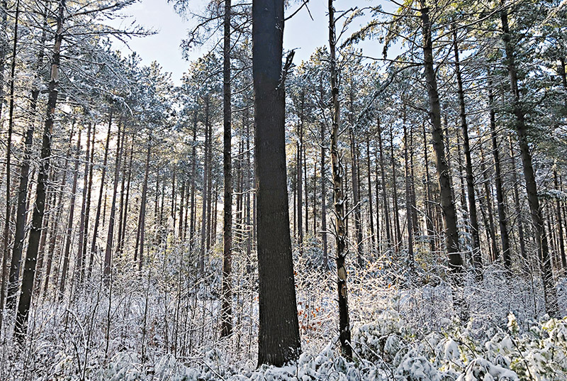
Larose Forest in Prescott and Russell is included in the draft NHS maps as a Core Natural area. Courtesy photo
Sandy Casselman
LJI Reporter
FINCH – United Counties of Prescott-Russell (UCPR) residents had several questions for South Nation Conservation (SNC) representatives during a recent virtual meeting.

SNC was hired by UCPR and the United Counties of Stormont, Dundas and Glengarry (SDG) to undertake a Natural Heritage Systems’ (NHS) study. SNC communications and outreach team lead John Mesman and SNC approvals team lead Alison McDonald hosted virtual presentations for both counties last week to report on the status of the study. The UCPR session was held Feb. 10.
The 45-minute information session included background information, along with an explanation of what an NHS study is, and why it is important. Time was also spent on outlining how the study might be used in the future, and how it will or will not impact residential properties and farmlands.
SNC defines a natural heritage system as a network of interconnected natural features and areas such as forests, lakes, rivers, agricultural lands, and wetlands. Municipalities are required by the province to identify NHS and preserve the diversity and connectivity of these features.
The main goals of the study include: identifying key natural heritage features and supporting areas; recognizing local linkages and wildlife corridors between natural heritage features; improving environmental policies; providing a scientific basis for land and water stewardship activities; protecting and enhancing regional biodiversity, indigenous species, and ecosystems; helping to mitigate the effects of climate change, such as flooding and drought; and, conserving natural legacy for future generations.
To view the session in its entirety, visit SNC’s YouTube page (youtube.com/SouthNationCA) where links to both the Feb. 9 and 10 meetings can be found. To view maps and other detailed information about the study, visit nation.on.ca/nhs.
Q&A with UCPR
When asked what is being done to stop clear-cutting practices in UCPR, McDonald said the municipal tree conservation bylaws are the most common way of doing that in Ontario. She said many municipalities have had such bylaws for years, and most try to work collaboratively with landowners through stewardship.
“There is always the option, if the municipality and the county decide it’s enough of an issue for them to enact those tree conservation bylaws; and I think those are being considered in North Glengarry currently and Alfred-Plantagenet,” she said. “That power truly and only rests with the municipality or the county. It’s not something that the South Nation can regulate. The one exception to that rule would be within Provincially Significant Wetlands (PSW). Our job is to make sure that no development or site alteration impact the hydrology of a wetland.”
As for incentives for private landowners, Mesman referred attendees to SNC’s many stewardship programs. A list of programs can be found on the SNC website.
Another resident asked if there was a way to stop big companies from buying farmlands, clearing those lands, and then releasing them to farmers with no regulations.
“It did come up as a concern in the agricultural community as well and, obviously, there’s always a fear when outside landowners come in who don’t know the values of the community and there’s a lot more stewardship and best management practices by farmers who live here than by farmers who don’t,” McDonald said. “Really there’s nothing that we or the municipality can do to prevent people from purchasing land.”
Several questions revolved around protecting specific areas in UCPR, including Alfred Bog, Dickinson Creek, and Jessup’s Falls. McDonald said that while she would not avoid responding to these types of questions, the answers would, unfortunately, not be satisfactory.
“We were able to protect part of the Alfred Bog and some of it was lost,” McDonald said. “There was a fund established at the time, so there are some funds left to purchase wetlands and to conserve them.”
Mesman added that the effort to save acres of Alfred Bog peat moss was spearheaded by the community. Neighbours worked to bring partners like the Nature Conservancy of Canada together to help direct more funding to that area and to put some of the land in public trust.
“We see that happening in places all over the region,” he said.
As for Dickinson Creek, McDonald said SNC is currently working with the Ministry of Natural Resources and Forestry (MNRF) to get updated information to determine if it has PSW status.
“If so, maybe there’s an opportunity to purchase more of those lands,” she said, noting that both the county and SNC have lands in that area. “I also understand the ministry may be holding funds related to being able to secure more land, so hopefully it’s going to be a good news story. You can tune in on Feb. 16 at Alfred-Plantagenet council where we’ll be giving a presentation, specifically on that topic.”
One viewer referenced the Jessup’s Falls escarpment, noting that it took years of work to protect the area and to keep the groundwater safe. Mesman acknowledged the hard work that went into this project, as well as many others throughout the area.
“Those are a lot of great community-led initiatives,” he said. “The people that lived in these communities valued these features and worked hard to protect them and we want to recognize that effort and we want to recognize that we share those values as well.”
As for protecting bogs, swamps or marshes on privately-owned land, McDonald said if it’s not identified as a PSW, there is a possibility for the municipality to make it a Locally Significant Wetland, at which point SNC could work with the municipality to regulate it.
In response to a question about municipal planning authorities developing bylaws to support conservation of the NHS corridors, McDonald said: “We really do hope that these maps and this landscape analysis is going to be used to direct things like stewardship, but also to direct things like bylaws. If you were going to pass a bylaw that would protect water courses, the ones along linkages would be considered the most important. We’re hoping that that is valuable information for these municipal planning authorities.”
A question was raised about core natural areas and whether they correspond to the headwaters for creeks and rivers.
“For those familiar with headwater drainage features, they are the beginning parts of a river or stream system and are often some of the most significant, especially in terms of managing water and managing water quality, and so we, through our clean water program, direct as much effort as we can to headwater drainage work to make sure that those areas are protected and contributing to healthy systems,” Mesman said. “There’s a number of good examples in this map that include good headwater drainage features.”
McDonald answered a question about how SNC collaborates with farmers.
“The original recommendation to look at stewardship incentives was born out of our agricultural forest committee,” she said, noting SNC has spent many years on various committees with farmers and other agricultural community representatives. SNC has used position papers from the Ontario Federation of Agriculture and other farming-related agencies when designing policies.
“Many of us live and grew up on farms in the area,” she said. “It’s something that we’ve spent a lot of time, working with our agricultural representatives. Collaborating is sort of working together on this policy and mapping stuff, but I think the more important collaborations are what come after, where we try to put some projects on the ground with people who live and work and play in the system.”

